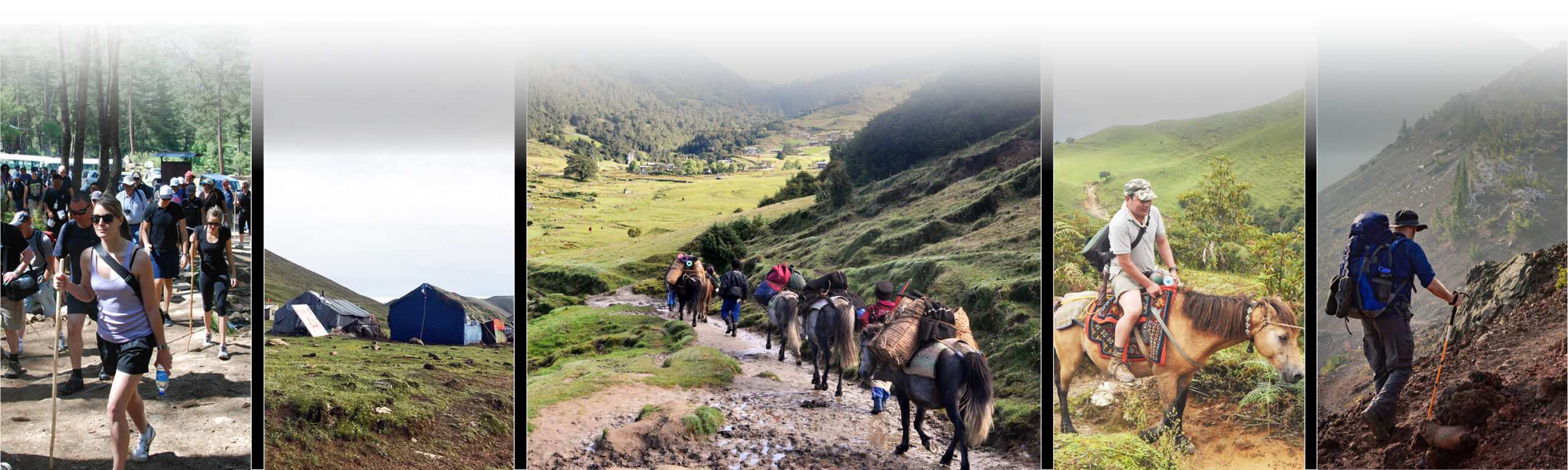
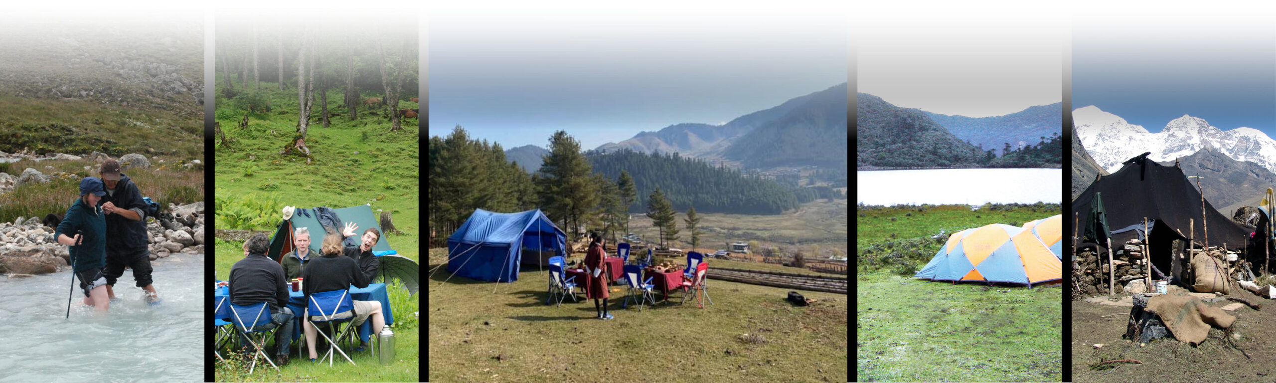
TREKKING TOUR
This breathtaking country has some of the finest trekking routes for the insatiable traveler and trekker. From short walks through scenic valleys and remote hamlets to challenging high altitude treks, Bhutan has it all. From being up close and personal to the snow capped peaks. You will also witness the magnificent array of flora and fauna the kingdom has to offer.
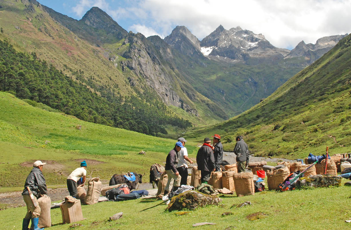
All Bhutan trekking tours include camping out along the trek trails with guides, ponies and cooks accompanying you all through the route you choose.
DAY 1 – Paro to Sharna Zampa
Your trek starts from the historic Drugyel Dzong (2580m). The Dzong is a 12km drive to the north of Paro valley from the hotel. You will meet your trekking crew here. After a short while you will start walking on a wide trail that tracks along the Pa Chhu (Paro river). The trail will slowly ascend where you will be walking through the countryside with views of rice paddies and fields of millet. As the valley widens you will find apple orchards, traditional Bhutanese farmhouses and a few small settlements of Mitshi Zampa and Sangatan. Following the route through blue pine forest you will be brought to the army post of Gunitsawa at 2810m where your trekking permits will be checked and stamped. You will then climb towards Sharna Zampa (2870m) after crossing Pa Chhu on a wooden bridge. You will be camping at Sharna Zampa in the meadows among the trees for the night.
DAY 2 – Sharna Zampa to Soi Thangkha
Just like the previous day, we will be following the trail following the Pachhu (Paro river). We will be ascending and descending through pine, oak and spruce forests. You will reach at Shingkharap after 2 hours of hiking and crossing several streams. This is a stone house at 3110m. You will then cross the bridge towards the left side of the river where you will be served a hot lunch. A little walk ahead is the trail junction. The left road is an old trade route to Tibet and the right route leads to the wooden bridge. We will be taking the latter route. After climbing through rhododendron forests and finally crossing the bridge again, we reach our camp at 3750m, which is amidst beautiful meadows.
DAY 3 – Soi Thangkha to Jangothang base camp
Today is not a long trekking day but it will involve a significant gain in altitude as your trail goes above tree line. As you take the path that ascends from our camp you will be brought to an army camp. Then you will follow the river above the tree line as well as enjoying the spectacular view of the surrounding mountain peaks. After walking through a very muddy section and passing a mani wall you will enter yak country. Inside a yak herder’ camp you will be served a hot filling lunch. After lunch, we walk past yak herder settlements of Soe and Takethang. Some common crops that people grow here are barley, potatoes and turnips. After your lunch, you will walk across a plateau and up a stream bed. You will pass Dangochang village to the beautiful campsite of Jangothang at an altitude of 4040m. From here, the views of Mount Jumolhari and Jichu Drake will take your breath away.
DAY 4 – Jangothang acclimatization
Today, you will do a four hours long acclimatization hike to the north of your camp. There isn’t really a trail but you will climb on an open and endless slope till you see the view of Mt Jichu Drakye (6989m). You can hike further up to 4895m (higher than Mount Blanc) to see the amazing view of Mount Jumolhari. You are likely to spot rare blue sheep, Himalayan rhubarb, griffon vultures, golden eagles and the our national flower – the blue poppy. In the foreground below the colossal Mount Jumolhari and its neighboring mountain, Jichu Drake is the Jangothang base. It is a flat grassy land with the ruins of an old fortress on a hillock. It is highly recommended for all trekkers to halt here as most people show signs of mountain sickness at this altitude. You will have the option to hike or to simply rest in camp. Both ways, it will be a very memorable day.
DAY 5 – Jangothang to Lingshi
Today’s trail follows the stream for half an hour and crosses the bridge to the right side. You will then start to climb up to the first ridge where you will be greeted by a breathtaking view of Jumolhari (7314m), Jichu Drake (6989m) and Tsherim Gang (6789m). You will then be walking on an almost flat track for sometime towards the valley and then you will have to climb to Ngye La pass at 4700m. After the pass, it is a gradual descent to the camp. You will get to enjoy the spectacular panoramic view of the peaks here and the Lingshi Dzong. If time permits, you can take a detour to this tiny fortress that is sits on a hilltop overlooking Lingzhi village. For centuries, Lingzhi Dzong was a way station for weary Buddhist pilgrims and was a defence fort against Tibetan and Mongol invaders. You will camp today at an altitude of 4010m.
DAY 6 – Lingshi to Chebisa
Perched on a hilltop with breathtaking views of green hills, meandering rivers and magnificent peaks is the Lingshi Dzong. For centuries, Lingzhi Dzong was a way station for Buddhist pilgrims. It was also a defence fort against Tibetan and Mongol invaders. Today is an easy day filled with pleasant walks through villages and yak herders’ camp. After lunch, a short walk will take you to Chebisa, a charming little village adorned with a beautiful crystal clear waterfall. You will camp by the side of a stream at an altitude of 3850m.
DAY 7 – Chebisa to Shoumothang
You will begin your trek with a steep climb up a ridge to Gogu La pass (4500m) which will take nearly four hours. It is common to spot rare blue sheep on the rocks near the top of this pass. After the pass you will make a descent in your route where you will pass through rhododendron bushes to a lunch stop. In the afternoon you will continue to walk along the trail with scattered ascents and descents. After crossing the stream, walking through rhododendron forests and yak herders camp, we arrive at Shakepasa at 3980m. After this point, you will be climbing steeply up to the northern side of the valley and passing by a few yak herder’s camp. We will then arrive at our camp located beside a stream at an altitude 4250m.
DAY 8 – Shoumothang to Robluthang
Today the trek begins by you walking through edelweiss bound trail and then a climb to Jari La pass at an altitude of 4700m. The snow capped peak visible to the south-east is Kangbum at 6526m. You will then descend to Tsarijathang valley. This valley is the summer residence of rare Himalayan Takins (national animal of Bhutan). From here on you may have to cross streams without a footbridge because in most cases these bridges are washed away. After crossing the stream, to the left the trail ascends till you reach Robluthang. It is a rocky meadow camp at an altitude of 4200m.
DAY 9 – Robluthang to Lingmithang
Today will be an exhilarating day as you will cross the highest pass in our entire trek. You will climb all the way up through boggy patches. As you follow this trail you will be crossing streams and spotting marmot holes and moraine. You will then reach the top of Shingchen La pass (5005m). You will be greeted with the view stunning view of the snow-covered Gangchenta or the Tiger Mountain (6840m) filling the northern horizon. After taking in the view you will descend through a rough rocky trail following the moraine river valley to Kango Chhu River. You will find that the path is quite narrow and you may be expected to cross a stream again and get yourself wet. After a fresh walk through cedar forests you will finally arrive at Lingmithang (4140m). Lingmithang is a beautiful campsite, with scattered meadows by the river with Tiger Mountain (Gangchenta) towering behind your campsite.
DAY 10 – Lingmithang to Laya
In the morning you will wake up to a superb view of Gangchenta peak. The walk to Laya is very pleasant with wonderful views. You will pass through a damp forest, filled with moss and singing birds. It is a pretty long walk through this uninhabited valley. You will also see a waterfall as you follow this trail. As you walk further, you will find yourself at a junction. The upper route will bring you to fields spotted with stone houses. Arrive at Laya village, the second highest settlement in the country, at an altitude of 3800m.
DAY 11 – Rest day at Laya
Today is a day you can temper to your taste. Explore Laya village and go visit any of the houses around. Hospitality is a big part of Bhutanese tradition. Even to a perfect stranger, traditional Bhutanese hospitality is extended and a cup of tea and Chang (local, wine) is always offered. You will notice that the people in this valley are very interesting especially their attire. Women in particular have very conspicuous attire, wearing conical bamboo hats decorated with turquoise and silver ornaments
DAY 12 – Laya to Koena to Gasa
Descend to army camp and join the Mo Chhu (Mother River of Punakha). Follow the river till you cross the bridge. After the bridge we will have to ascend and descend several times, through juniper and fir forests until you reach Koena at an altitude of 3800m. You will meet your car and driver here to transfer you to Gasa village. The drive is through the fir, spruce and rhododendron forest and after descending almost 1250m you reach Gasa. Here you can have a relaxing dip in the Tshachu or the hot spring which is located below your camp. It is going to be a treat relieving you from any muscle aches after a long trek. Overnight Gasa camp at 2900m. This marks the end of the this trek and tomorrow you will drive to Punakha valley.